A mid-rise project in Uptown Charlotte was stalled because the structural engineer needed the site class for seismic design. We mobilized a MASW array along the sidewalk and recorded the shear wave velocity profile down to 30 meters in a single day. That data gave the team the VS30 value they needed for ASCE 7 site classification. Without it, the foundation design would have been either overconservative or non-compliant. This is why we run surface wave surveys for architects and contractors before they lock in their geotechnical model. The method works well even in noisy urban environments like Charlotte, where traffic vibrations are constant but the signal processing can still extract a clean dispersion curve.
A single MASW line in Charlotte can replace two or three boreholes for seismic site classification, saving both time and mobilization cost.
Scope of work
Area-specific notes
The biggest risk we see in Charlotte is assuming the soil profile is uniform across a site. Saprolite can grade from stiff clay to decomposed rock within a few meters. A single borehole might miss that transition. MASW covers a continuous line of hundreds of meters, so we catch lateral changes that could affect foundation bearing or liquefaction potential. In residential subdivisions near Lake Wylie, for example, we found a buried channel of loose sand that no borehole had hit. That discovery changed the site class from C to D and triggered a deeper pile design. Without the surface wave survey, the slab would have settled unevenly within the first year.
Standards used
ASTM D4428 / D4428M — Standard Test Methods for Crosshole Seismic Testing, ASCE 7-22 Section 11.4 — Site Class Definitions Based on VS30, IBC 2021 Chapter 16 — Seismic Design Criteria
Linked services
Standard MASW Survey (1 line)
One 2D profile up to 200 m long, including dispersion curve inversion and VS30 report. Suitable for single-building sites or small subdivisions. Delivered in 5 business days.
Multi-line MASW + HVSR Package
Three or more survey lines with a passive HVSR measurement for bedrock depth confirmation. Ideal for large commercial plots or seismic microzonation studies. Includes a full site class map.
Typical parameters
Top questions
How deep does a MASW survey reach in Charlotte's soil conditions?
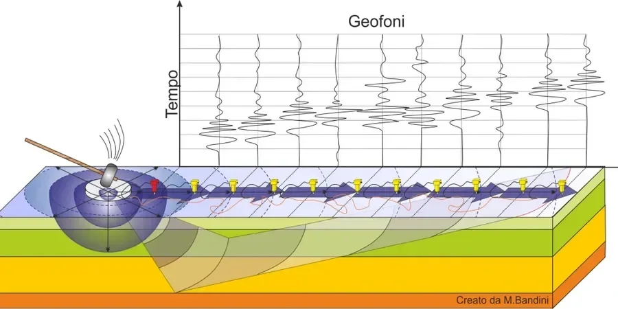
In typical Charlotte saprolite and residual soil, a MASW survey with a 24-geophone spread and a sledgehammer source reaches 25 to 35 meters. For deeper targets, we use an accelerated weight drop or a longer spread to push the depth beyond 40 meters. That covers the full VS30 requirement.
What is the typical cost range for a MASW survey in Charlotte?
For a single line survey up to 200 meters, the cost ranges between US$1,630 and US$3,000 depending on site access, line length, and reporting detail. Multi-line packages or surveys requiring a weight drop source fall at the higher end.
How does VS30 from MASW compare with VS30 from a downhole test?
Both methods give a shear wave velocity profile, but they sample different volumes. A downhole test measures the column directly around the borehole, while MASW averages the velocity over a horizontal distance of 50 to 100 meters. For site classification under ASCE 7, MASW is often preferred because it captures lateral variability that a single borehole might miss.
Can MASW be done on a site with existing pavement or utilities?
Yes. MASW is a surface-based method that works on asphalt, concrete, or grass. The geophones and source plate sit on the surface, so underground utilities do not interfere as long as we avoid direct hits. We coordinate with the client to mark known utility lines before the survey to keep the crew safe.