We worked on a road widening project along Albemarle Road a few years back where the existing drainage had completely failed. The subgrade was essentially a sponge of residual clay and silt, holding water for weeks after a storm. That experience taught us that geotechnical road drainage in Charlotte isn't just about pipes and ditches — it starts with understanding how water moves through these deep saprolite layers. Before you lay a single foot of pipe, you need to know the permeability profile of the soil column. That's why we always run in-situ permeability tests on site; lab values on remolded samples don't tell you the real flow paths through the weathered rock fabric.
The B-horizon clay in Charlotte often has Ksat below 10⁻⁶ cm/s — that is the layer that traps water and destroys road bases.
Scope of work
Area-specific notes
The biggest mistake we see contractors make in Charlotte is assuming that a few gravel-filled trenches along the road edge will fix drainage. They dig a trench, lay some perforated pipe, backfill with stone — and then wonder why water still ponds on the pavement. The problem is that the trench itself acts as a collection conduit, but without a proper outlet or connection to a positive outfall, it just becomes a bathtub. The water enters the stone, hits the low-permeability clay at the bottom, and sits there. We've seen subgrade moisture contents of 35% or more in those trenches, turning the base into a slurry within three years.
Standards used
FHWA HEC-22 (Urban Drainage Design Manual), ASTM D3385 (Infiltration Rate of Soils in Field Using Double-Ring Infiltrometer), ASTM D2434 (Permeability of Granular Soils, Constant Head), NCDOT Drainage Design Manual (Chapter 9: Subsurface Drainage)
Linked services
Field Infiltration Testing & Permeability Profiling
Using double-ring infiltrometers and borehole permeameters, we measure Ksat at multiple depths along the proposed road corridor. Results are plotted against the soil profile to identify restrictive layers and design drainage depth.
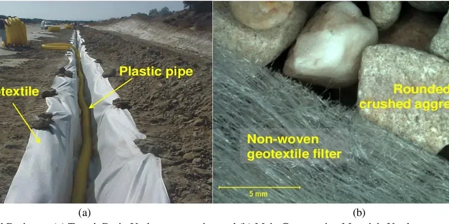
Subsurface Drainage Design & Filter Specification
We design trench drains, curtain drains, and edge drains with geotextile filter fabric. Pipe sizing follows the Rational Method, and we specify aggregate gradation to prevent clogging while maintaining flow capacity.
Outfall & Slope Stability Assessment for Drainage
We analyze the receiving slope for erosion and shallow slide risk when concentrated drainage is discharged. Using FHWA slope stability methods, we confirm the outfall location won't trigger a failure plane.
This service complements our laboratory testing work for a complete project analysis.
Typical parameters
Top questions
How deep should a road drainage trench be in Charlotte's clay soils?
For Piedmont residual clays, the trench invert should be at least 24 to 36 inches below the pavement subgrade surface. This places the drainage below the active zone of moisture fluctuation and into the B-horizon where lateral flow is more predictable. The trench width is typically 12 to 18 inches, and the pipe invert should have a minimum 0.5% slope.
Do I need a geotechnical drainage study for a small subdivision road?
Yes, even a 500-foot road can fail if drainage isn't designed for your specific soil. We've seen subdivision roads in Charlotte develop longitudinal cracks and edge settlement within two years because the contractor skipped drainage on the low side. A targeted study — even just three test pits and two infiltration tests — can save you tens of thousands in repairs.
What is the typical cost range for a geotechnical road drainage study in Charlotte?
For a standard drainage investigation on a local road (4 to 6 test pits, infiltration tests, and a design report), the cost typically falls between US$950 and US$2,620 depending on site access and the number of tests required. Larger arterial projects can go higher, but this range covers most small to medium subdivisions.