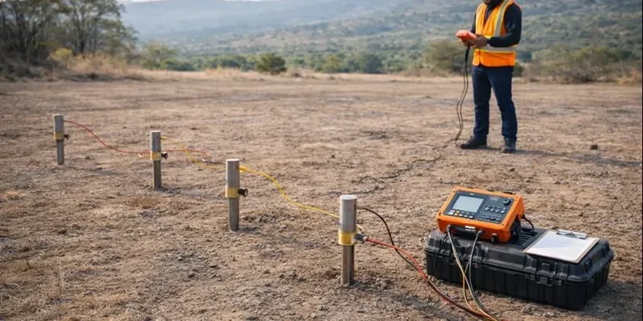
Charlotte sits on the Carolina terrane, a mix of metamorphic bedrock and residual soils that can vary dramatically within a single block. Saprolite depths shift from 5 to over 30 feet, and the water table fluctuates with seasonal rains. That is why we deploy electrical resistivity / VES profiling early in the design phase. This geophysical method measures subsurface resistivity contrasts to locate weathered zones, fractures, and groundwater without a single borehole. Before we mobilize a rig, we often pair this with a georadar survey for shallow utilities and a MASW profile to capture shear-wave velocity. The result is a 2D or 3D resistivity model that guides where to sample and where to avoid.
Resistivity surveys in Piedmont soils reveal weathered bedrock profiles that boreholes alone often miss, saving time and drilling costs.
Scope of work
Area-specific notes
A 10-story apartment tower in South End Charlotte recently hit a buried schist pinnacle during augering — a feature the geotechnical report had missed. Without a resistivity survey, the team had to redesign the foundation from spread footings to a mat on deep piles, adding six weeks and 15% to the substructure budget. We have seen similar surprises in the University City area, where saprolite grades into unweathered rock without warning. Running a VES line before drilling reduces that risk. It highlights lateral changes in resistivity that correspond to hard rock boundaries or groundwater channels. In Charlotte's Piedmont terrain, that data is worth more than the cost of the survey itself.
Standards used
ASTM D6431-18 (Standard Guide for Using the Direct Current Resistivity Method), ASTM G57-06 (Field Measurement of Soil Resistivity), IBC 2021 Section 1803 (Geotechnical Investigations)
Linked services
2D Resistivity Profiling
A multi-electrode line up to 400 m long, ideal for linear projects like pipelines, roads, and utility corridors. We deliver a contoured pseudosection with interpreted layer boundaries and anomalous zones.
Vertical Electrical Sounding (VES)
A single-point depth sounding using expanding electrode spacing. Best for site-specific depth-to-bedrock or water-table determination. Typical depth range: 10 to 60 m.
This service complements our laboratory testing work for a complete project analysis.
Typical parameters
Top questions
How much does an electrical resistivity / VES survey cost in Charlotte?
For a standard 2D profile with 56 electrodes and 5 m spacing, the range is between US$590 and US$950. VES soundings at a single point run around US$450 to US$700, depending on depth and accessibility.
What depth can a VES survey achieve in Piedmont soils?
In Charlotte's residual soils and saprolite, a VES with a 100 m electrode spread can resolve layers down to approximately 40 m. The actual depth depends on resistivity contrast and electrode spacing.
How does resistivity data compare to direct drilling?
Resistivity provides continuous lateral coverage between boreholes, while drilling gives point samples. We recommend using both: VES to map the stratigraphy, then targeted boreholes for classification and strength tests. That combination cuts drilling volume by 30-50% without losing confidence.
Can resistivity detect groundwater in Charlotte's bedrock?
Yes. Fractured gneiss and schist in the Charlotte area often contain water that appears as low-resistivity zones (below 500 ohm-m) in the inverted model. We can identify potential yield zones before test wells are drilled.
Is the survey affected by existing utilities or pavement?
Pavement and rebar can create noisy data. We plan the electrode line to avoid known metallic infrastructure, and use solid inversion filters to minimize interference. In developed areas we also run a utility GPR beforehand to map underground obstructions.